


| Story Views | |
| Now: | |
| Last Hour: | |
| Last 24 Hours: | |
| Total: | |
Forecast Remains The Same

Written By: Scott Hetsko
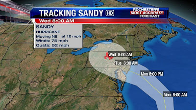
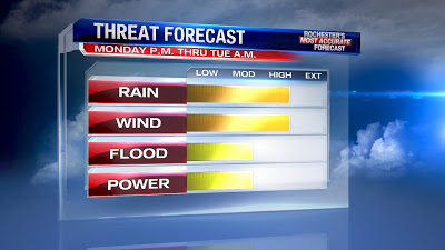
Hurricane Sandy will make landfall as a category one storm with winds near 75 mph. Sandy will move quickly through Southern Pennsylvania late Monday evening and slowly weaken. Our expectations remain about the same with respect for rainfall amounts and wind velocity. Rain will fall heaviest Monday night and early Tuesday. Totals will range between 1 to 3.5″ across the area with the highest amounts likely in the central Genesee valley and hills of the central Southern Tier.
Peak wind gusts will be found in the higher elevations and along the shoreline of Lake Ontario. In these regions, gusts between 50-60 mph are likely between 9 p.m. and 4 a.m. Monday night and Tuesday morning. Wave heights on the lake could be near 20 ft due to the duration of the wind coming across the longest fetch of Ontario with a NE wind. Once the wind shifts East and weakens, that wave action will diminish. Lake shore flood warnings are in effect.
As for the threat of power outages, my largest concern is the direction of the wind. Trees in the Northeast are used to a prevailing West to Northwest wind. As a result, the root structure is strongest on that side of trees in our area. A strong, sustained Northeast wind may result in trees knocking out power. I would advise those who have older trees in their neighborhood to pay particular attention.
Be safe and keep it here and on line for updates.
Scott
RochesterHomepage.net/
2012-10-28 23:41:20
Source: http://rhpweatherblog.blogspot.com/2012/10/forecast-remains-same.html
