


| Story Views | |
| Now: | |
| Last Hour: | |
| Last 24 Hours: | |
| Total: | |
Tracking Sandy Update…

Written by John DiPasquale:
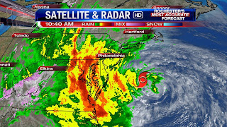
Look at Sandy!! The intense storm/hurricane with 90 mph max sustained winds with gusts b/w 110 & 120 as of 11am this morning will likely strengthen even a bit more before making landfall this evening sometime b/w 7 & 10 in Southern New Jersey. Sandy will likely create a dangerous, life threatening storm surge of several feet from the Virginia coast to the Southern New England coastline. The storm surge will be enhanced higher tide due to a full moon tonight too just adding insult to injury along the coast!
SANDY’S IMPACT ON US HERE IN WNY…The worst of this storm will likely impact WNY, including Rochester, b/w about 6 Monday evening through Tuesday morning. Winds will likely become sustained b/w 35 & 45 mph with gusts from 50 to 60 mph, & possibly even a bit stronger than that along the south shore of Lake Ontario, high terrain & southern ends of the Finger Lakes. With that being said, we do believe there will be some downed trees & tree limbs, which will lead to some power outages during this time frame. So be sure to have back up power & light sources. Rainfall will likely range from 1 to as much as 3 inches, & that may cause limited flooding in spots, but there should be no major flooding in the area due to falling rains. However, along the south shore of Lake Ontario, & maybe even a bit on the south ends of the Finger Lakes, there will be some flooding, as waves of 12 to 18 feet with a few maybe even a bit higher crash ashore!
All will slowly quiet down during the day Tuesday, but it will remain a nasty day, especially through the early afternoon. Temperatures will likely warm into the 50s late today through Tuesday, with even an outside chance of hitting 60 Tuesday thanks to warmer air being thrown in off the ocean. The rest of the week will remain somewhat unsettled at times & brisk, including for all the little ghosts & goblins Wednesday. Stay tuned to News 8 for all the details & updates through the rest of today & Tuesday on the web & on-air.
RochesterHomepage.net/
2012-10-29 11:41:17
Source: http://rhpweatherblog.blogspot.com/2012/10/tracking-sandy-update.html
