| Online: | |
| Visits: | |
| Stories: |

Ice Storm Slams Ohio River Valley States, Within TheWeatherSpace.com Ice Storm Warning Zone

(TheWeatherSpace.com) – An Ice Storm Warning was issued 12-18 hours before a major ice storm hit the Ohio River Valley bordering states. The alert is a custom alert issued by the work done here at TheWeatherSpace.com. Do not wait for your local news or government weather office to issue these because Kentucky did not have one today when they should have. Read details below on why this was issued.
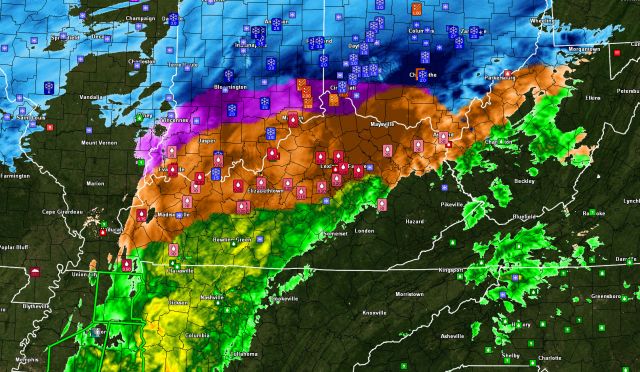
On Monday evening the grids here at TheWeatherSpace.com showed Ice Storm Criteria accumulations across Arkansas, Missouri, Tennessee, Kentucky, Southern Indiana and Southern Ohio with the following image.

I issued the ice storm warning to the alert system, our Facebook page, and the website at 8:15pm Central Standard Time on Monday evening, February 4, 2014. The wording stated … “A front lifting through the region will start an Ice Storm across Arkansas on Tuesday morning. This Ice Storm will be hardest hit near the Little Rock, AR zones where 0.50 to 0.75″ of ice is possible! Over the day it’ll move east-northeast across KY and OH … Everywhere in the warning zone has 0.25″ or higher probabilities …” Graphic provided below …

The radar image on Tuesday evening confirmed reports of widespread 0.25″ reports with reports as high as 0.75″ across Western Kentucky! Power is out in many areas so I’m hoping at least my viewers got prepared. This ice storm brought 0.50″ reports to Arkansas as well. It is continuing across Southern Ohio